Standing on the edge of the cliffs overlooking Kaputaş Beach offers a thrill that goes far beyond the typical sunbathing experience. While hundreds of visitors crowd the sands below, a silent and rugged path winds its way above the canyon, offering one of the most photogenic daily stages of the entire Lycian Way.
This route is not just a walk; it is a journey through ancient geography, carrying the scent of wild thyme and the sight of endless Mediterranean blue.
- Distance: Approximately 14 kilometers (varies slightly depending on exact starting point)
- Difficulty: Moderate (due to rocky terrain and heat)
- Duration: 4 to 5 hours for an average hiker
- Elevation Gain: Moderate climbs with a long descent
- Water Sources: None on the trail (critical)
Trail Overview: What to Expect
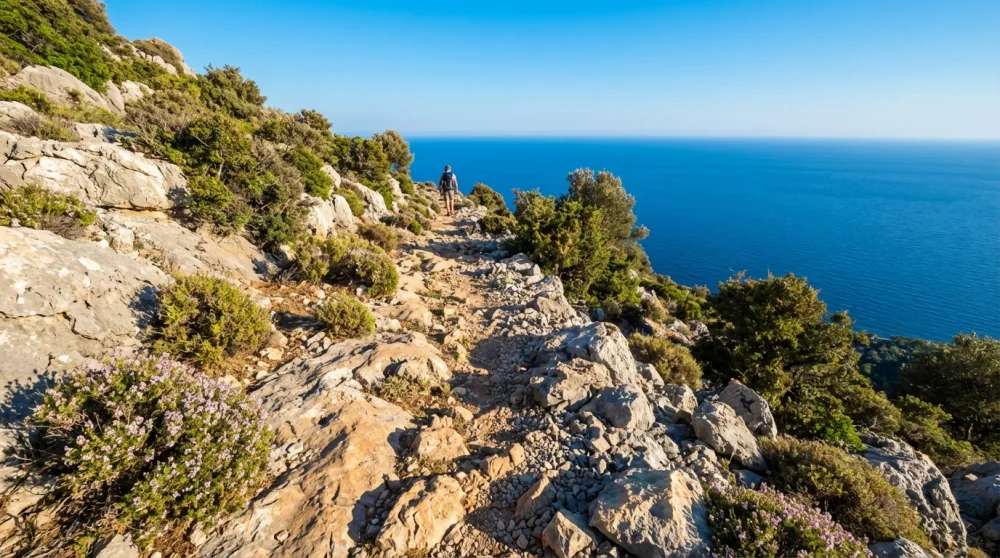
The segment between Kaputaş and Kaş is characterized by its raw, exposed limestone terrain and constant views of the sea. You are not walking through a dense forest here; you are traversing the open coastal plateau. The ground is often uneven, filled with loose rocks and sharp karst formations that demand your attention.
This openness means two things: spectacular, unobstructed views and full exposure to the sun. The colors you will witness range from the electric turquoise of Kaputaş to the deep sapphire of the open Mediterranean.
The vegetation consists mainly of low-lying maquis, thorny bushes, and hardy olive trees, which do not provide significant shade. This route appeals to hikers who enjoy solitude and vast horizons rather than shaded woodland walks.
Logistics: How to Get to the Trailhead
Starting this hike requires a bit of planning regarding transportation. You can easily catch a dolmuş (minibus) from Kaş Otogar heading towards Kalkan or Patara. These shuttles run frequently throughout the day.
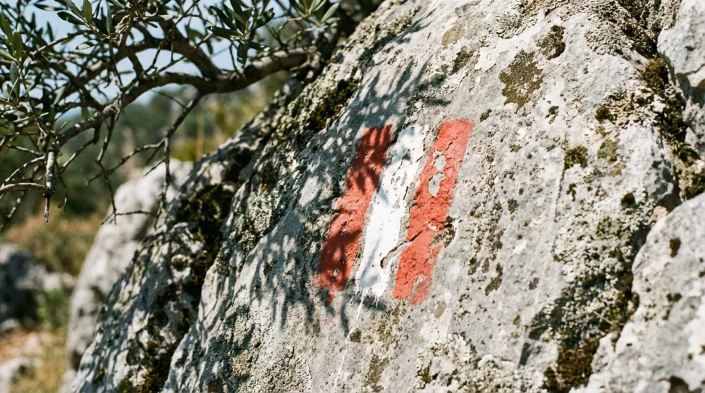
The critical part is where you get off. Do not go all the way down to the beach level if you want to save energy. Ask the driver to drop you off at the junction where the road curves above the canyon. The official waymarks for the Lycian Way are painted red and white, but they can sometimes be faded or hidden by construction works near the road.
Having a working GPS on your phone is essential here. To ensure your maps load quickly and you stay connected for safety, checking out the best SIM card for tourists in Turkey before you head out is a smart move.
Step-by-Step Hiking Guide
The Ascent from Kaputaş
The hike begins with a climb. You leave the asphalt and immediately engage with the vertical nature of the coast. The trail takes you up along the rim of the Kaputaş Canyon. This section can be physically demanding as your muscles warm up, but the rewards are instant.

Looking back, you get a bird's-eye view of the beach and the winding road that looks like a ribbon cut into the mountainside. Take your photos here, as the perspective is unique.
The Coastal Plateau
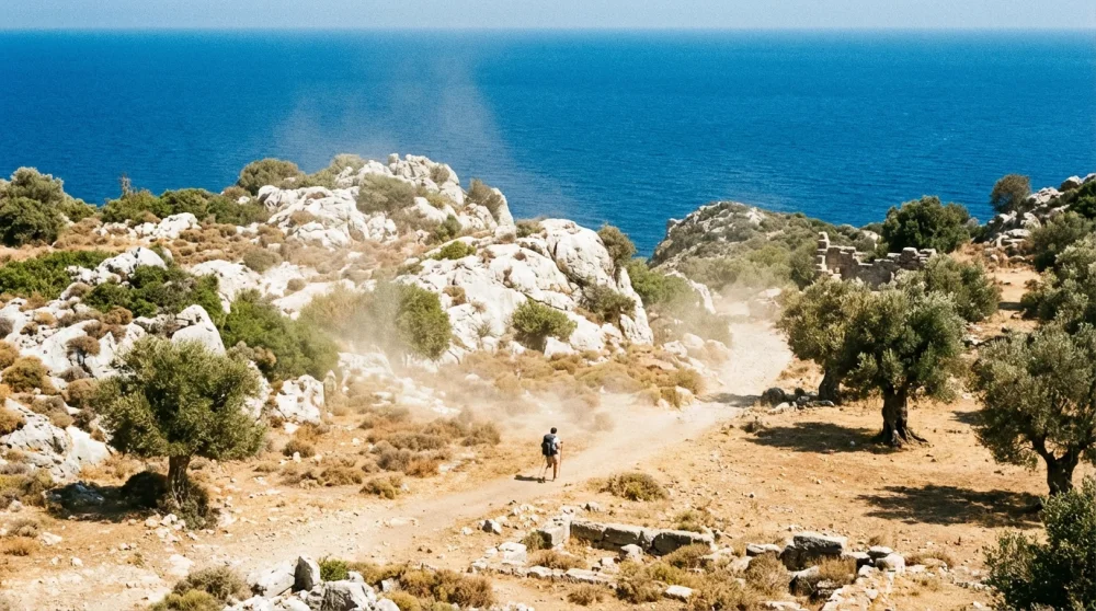
Once you conquer the initial ascent, the trail levels out into a rolling plateau. This is the longest section of the hike. You will weave through old stone walls and abandoned agricultural terraces.
The silence here is profound, broken only by the sound of goats or the wind. The path generally follows the coastline but stays high up, meaning you have a constant breeze. Be careful with your footing, as the loose gravel can be slippery even on flat sections.
Descending into Kaş
As you approach the final third of the hike, the town of Kaş comes into view. You will see the Greek island of Meis (Kastellorizo) sitting prominently across the water. The descent is long and can be tough on the knees. You will pass by the ancient walls of Phellos if you take a detour, but the main track leads you directly towards the peninsula views. The trail eventually merges with dirt roads and then the paved streets of Kaş, dropping you right into the heart of civilization.
Critical Tips for a Safe Hike
Water and Shade
This cannot be stressed enough: there is absolutely no water source on this entire route. You must carry at least 2 to 3 liters of water per person. The sun reflects off the white rocks, creating an oven effect even on mild days. Dehydration is the biggest risk on this specific stage. Do not rely on finding a spring; bring everything you need.
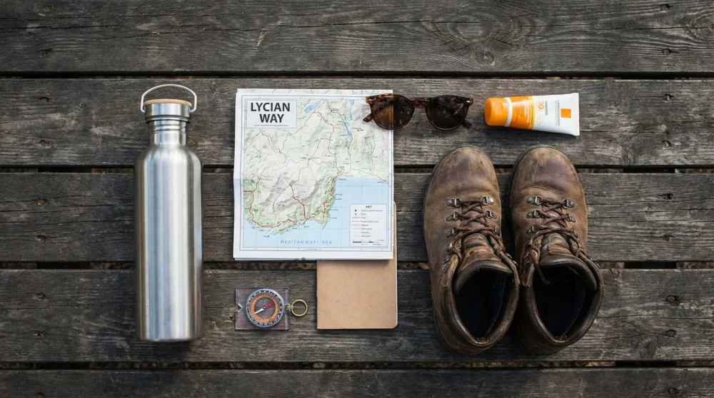
Proper Gear
Leave the flip-flops and basic sneakers at the hotel. The sharp limestone rocks will destroy soft-soled shoes and hurt your feet. You need trail running shoes or lightweight hiking boots with good grip. Also, long pants or high socks are beneficial because the thorny low-lying bushes can scratch your legs significantly.
Best Time to Hike
Avoid this trail during the peak heat of summer, specifically July and August, unless you start at sunrise. The ideal times are spring (April-May) when the wildflowers are blooming, or autumn (September-October) when the air is clearer and the sea is still warm enough for a post-hike swim.
Post-Hike Rewards in Kaş
Arriving in Kaş after hours of rugged terrain feels incredibly satisfying. The trail ends near the upper part of the town, allowing you to walk down through the narrow, bougainvillea-filled streets. You can head straight to the harbor for a well-deserved iced coffee or a meal. The contrast between the silent, dusty trail and the lively, charming atmosphere of Kaş makes the physical effort completely worth it. Exploring more of Turkey starts with these kinds of authentic, on-the-ground experiences.
![Orca Whale Watching in Washington: The Ultimate [year] Guide (Seattle & San Juan Islands)](https://www.rotasenin.com/uploads/2026/01/washington-best-time-to-see-orca-whale-watching.webp)
![10 Cheapest Places for Skydiving in the World ([year] Price Guide)](https://www.rotasenin.com/uploads/2026/01/cheapest-skydiving-destinations-cuautla-mexico.webp)
![Museumplein Amsterdam: Things to Do, Museums & Events ([year])](https://www.rotasenin.com/uploads/2026/01/museumplein-amsterdam-three-museums.webp)


Comments (0)
Sign in to comment
Report